Climate change impacts on suspended sediment loads in New Zealand
Description
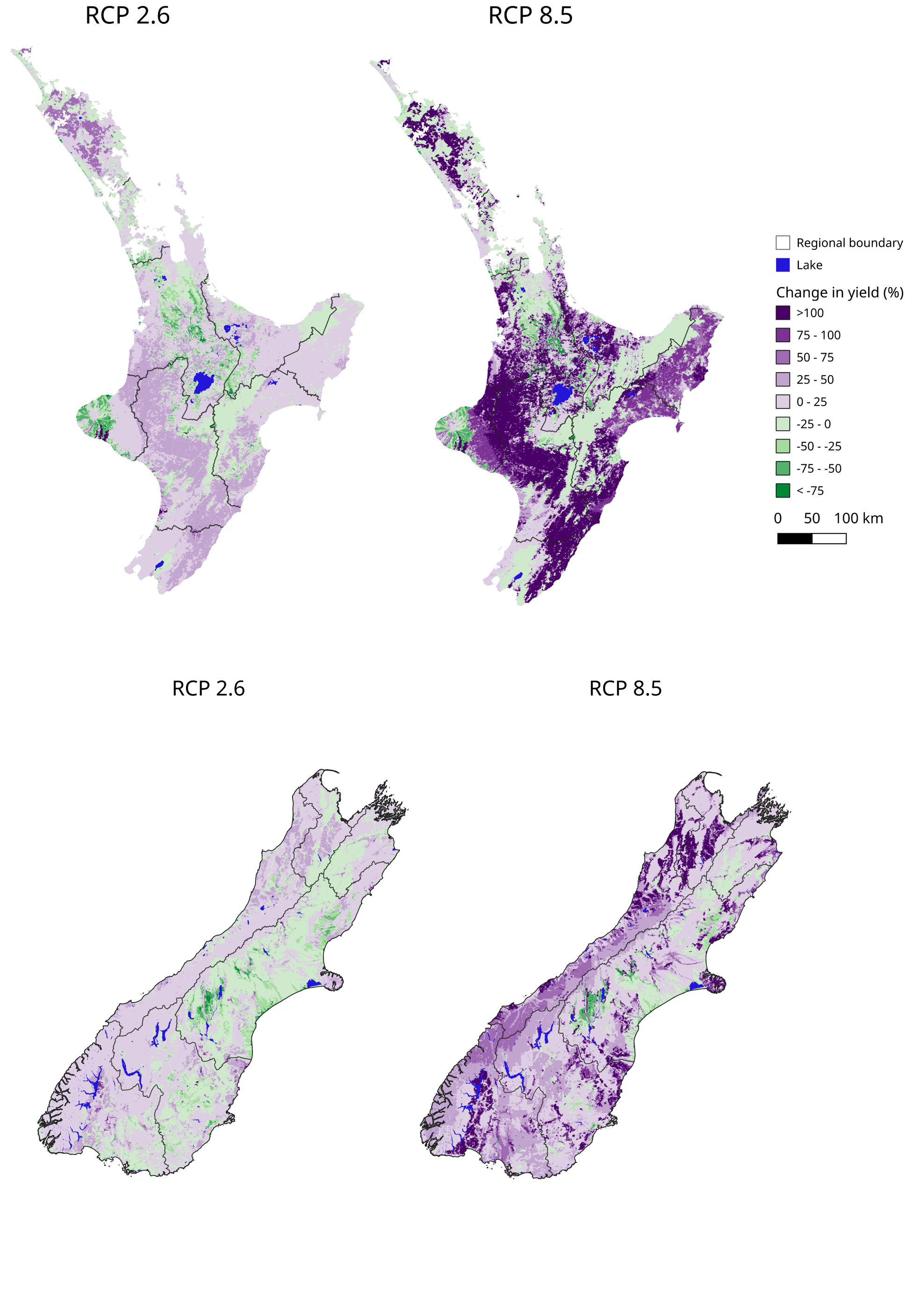
This dataset provides modelled median baseline and future changes in net accumulated mean annual suspended sediment load and local suspended sediment yield for REC2 watersheds by mid- and end-century (2040 and 2090) for four greenhouse gas emissions pathways from the IPCC 5th assessment report.
Date: April 2023 Version: v1
Owner: Manaaki Whenua - Landcare Research
Contact: Dr Hugh G. Smith, Manaaki Whenua - Landcare Research
Link to report / paper
Climate change impacts on erosion and suspended sediment loads in New Zealand
Preview Image
Dataset attributes
| Spatial extent | New Zealand |
|---|---|
| Spatial resolution | REC2 watersheds |
| Temporal extent | 1995 - 2090 |
| Temporal resolution | Multi-decadal annual average |
| Evaluation method (Validation) | NZeem model calibrated with instream data (see Dymond et al., 2010). Dymond, J. R., Betts, H. D., & Schierlitz, C. S. (2010). An erosion model for evaluating regional land-use scenarios. Environmental Modelling & Software, 25(3), 289-298. |
| Evaluation result (Numeric) | None |
| Evaluation result (Categorical) | None |
| Uncertainty method | |
| Uncertainty data format (Numeric) | None |
| Uncertainty data format (Categorical) | None |
Methodology
In response, we have developed a framework for estimating erosion and suspended sediment loads under climate change for use with existing national models. The new framework improves on previous national-scale erosion and sediment load modelling (e.g. Neverman et al. 2019; Monaghan et al. 2021) by:
- partitioning hillslope-derived sediment loads into mass movement and surface erosion contributions for soft-rock hill-country terrain
- representing the trapping and storage of sediment in lakes
- replacing the use of a spatially uniform estimate of the proportional contribution from riverbank erosion to total loads (i.e. 18% of total load in every catchment) with a spatially variable estimate of bank-derived loads in lowlands
Fitness for purpose / limitations
This table indicates whether the dataset is suitable for different types of questions at different scales.
Note: Users should carefully consider their purpose as this dataset may not be suitable.
| Operational | Absolute | Relative | Screening/scoping | |
|---|---|---|---|---|
| Block/farm | No | No | Maybe | Maybe |
| Multi-farms(5+) | Maybe | Maybe | Maybe | Maybe |
| Catchment | Maybe | Maybe | Yes | Yes |
| National/regional | Yes | Maybe | Yes | Yes | Caveat(s) | These model outputs are designed for national-scale assessment of the relative differences in the impact of climate change on erosion and suspended sediment loads between regions. Caution should be taken when using the data at finer resolutions (i.e. catchment to individual REC2 watersheds) due to limitations in the ability of the model to represent erosion processes at this scale. |
Data and Resources
-
Climate change impacts on erosion and suspended sediment loads in New ZealandPDF
License: CC BY-NC-ND 4.0 Attribute to: Manaaki Whenua - Landcare Research...
-
Median suspended sediment loads under climate changeGPKG
License: CC BY 4.0 Attribute to: Manaaki Whenua - Landcare Research...
-
Median suspended sediment yields under climate changeGPKG
License: CC BY 4.0 Attribute to: Manaaki Whenua - Landcare Research...
-
Climate change impacts on suspended sediment loads in New Zealand: data dictionaryPDF
License: CC BY 4.0 Attribute to: Manaaki Whenua - Landcare Research...
-
Climate change - Suspended sediment - Yield_PREVIEW.pngPNG
License: CC BY 4.0 Description This is the data preview image for the...