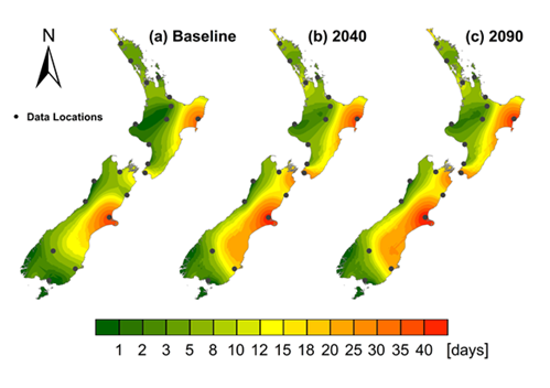
Forest fire danger (1990s, 2040, 2090)
Description
Annual frequency of Very High and Extreme forest fire danger during the Oct-Apr fire season - 1990s, 2040, 2090.
Date: Oct 2011 Version: v1
Owner: Scion
Contact: Mr Steve Wakelin, Scion
Link to report / paper
Preview Image
Dataset attributes
| Spatial extent | New Zealand |
|---|---|
| Spatial resolution | Very coarse |
| Temporal extent | Decadal snapshots: 1990s, 2040s, 2090s. |
| Temporal resolution | Annual (Oct-Apr) |
| Evaluation method (Validation) | None |
| Evaluation result (Numeric) | |
| Evaluation result (Categorical) | |
| Uncertainty method | |
| Uncertainty data format (Numeric) | |
| Uncertainty data format (Categorical) |
Methodology
The key steps included:
- Definition of future climate change scenarios for the 2050s (2040-2059) and 2080s (2070-2089) from improved statistical downscaling [and RCM approaches], and methods for incorporating future climate variability in fire danger calculations.
- Updating of existing fire climate databases to include up-to-date data (covering the full 1990s (1980-1999) current climate base period).
- Provision of offsets for weather elements used to determine future fire danger (i.e. changes in temperature, relative humidity, wind speed and rainfall) from statistical downscaling.
- Undertaking ‘control’ and climate change scenario runs of the RCM to determine current and future climate under different emissions scenarios, and extraction of RCM model outputs (weather changes) for use in calculating future fire dangers.
- Modification of current station fire weather records to account for projected changes in weather inputs for the 2080s from the selected climate change scenarios and downscaling [and RCM modelling] approaches, and calculation of future fire dangers.
- Statistical comparison of current and future fire dangers for the various scenarios and modelling approaches, and mapping of projected regional changes.
Fitness for purpose / limitations
This table indicates whether the dataset is suitable for different types of questions at different scales.
Note: Users should carefully consider their purpose as this dataset may not be suitable.
| Operational | Absolute | Relative | Screening/scoping | |
|---|---|---|---|---|
| Block/farm | No | No | No | Maybe |
| Multi-farms(5+) | No | No | Maybe | Maybe |
| Catchment | No | No | Maybe | Maybe |
| National/regional | No | No | Maybe | Maybe | Caveat(s) | Coarse resolution; needs to be updated with information published in 2022. |
Data and Resources
-
Assessment of multiple climate change effects on plantation forests in New Zealand (Review paper 2018)PDF
License: CC BY 4.0 Attribute to: Scion Description This study synthesizes...
-
Climate change Forest fire risk (2022, 2040, 2090)SHP
License: CC BY 4.0 Attribute to: Scion Description The .zip file contains 3...
-
Climate_change_Forest_fire_risk_PREVIEW.pngPNG
License: CC BY 4.0 Description This is the data preview image for the...