Multiple crops suitability & yield
Description
Mulitple crop suitability information includes:
- a pdf with maps of all the crop suitability and yield information (Apr 2022, v1)
- a table with the suitability rules for all of the relevant crops (Dec 2023, v2)
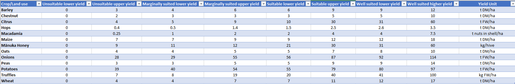
- a table with the yield ranges for all the relevant crops (Dec 2023, v2)
Date: December 2023 Version: v2
Owner: MPI, Plant & Food Research, Manaaki Whenua - Landcare Research, NIWA
Contact: Dr Steve Thomas, Plant and Food
Preview Image
Dataset attributes
| Spatial extent | New Zealand |
|---|---|
| Spatial resolution | N/A |
| Temporal extent | 30 year average, climate data 1971-2000 |
| Temporal resolution | Yield values are mean annual estimates |
| Evaluation method (Validation) | Expert assessed |
| Evaluation result (Numeric) | N/A |
| Evaluation result (Categorical) | N/A |
| Uncertainty method | None |
| Uncertainty data format (Numeric) | |
| Uncertainty data format (Categorical) |
Methodology
The land suitability concept is used to characterise the degree of fitness of a given environment for specific agricultural activities. The key principle in the method is that land suitability for the growth of different plant species can be estimated from geo-referenced information on climate (e.g. temperature and rainfall regimes), soil (e.g. soil depth and pH) and terrain conditions (e.g. slope and aspect). The suitability model utilises a wider range of GIS-rules adapting the method from Kidd et al. (2015) and simplified "categorical" parameter ranges. To quantify land suitability for a given environment, the model translates the "biophysical attributes" into "suitability indexes" through crop-specific "suitability rules". For example, suitable growing conditions might occur between temperature ranges of 5 to 25°C for a given crop, with an optimum within a narrower range (e.g. 15 and 20°C). Suitability classes (4 classes were defined, they are well suited, suitable, marginally suited, and unsuitable) for different attribute-crop combinations can be estimated based on such suitability rules. The overall suitability index of a crop at a specific location takes value from the worst index (limiting factor) out of all the attributes index at that location. Suitability rules were either generated from the literature and through consultation with crop-specific experts. Each crop went through one or more iterations where experts would evaluate the resulting national map from current rules, identify areas where suitability was not sensible and suggest improvements to the rules to obtain expected spatial patterns.
The suitability rules are simplifications of biophysically sound principles that operate at a much lower scale of organisation (e.g. crop and plant physiological responses to the environment). Such simplification is necessary, given that suitability assessments are performed at the landscape level.
Yield ranges for each suitability class were estimated by crop experts. The upper range of the well-suited class is based on the maximum "field" yields observed in New Zealand. Upper and lower bounds of national average crop yields are used for the suitable class range. Yield ranges in the marginally suited class are those limited by the environmental conditions with varying impact from year to year. Environments where yields are predicted to be zero or crops are considered uneconomic to harvest are classed as unsuitable.
Fitness for purpose / limitations
This table indicates whether the dataset is suitable for different types of questions at different scales.
Note: Users should carefully consider their purpose as this dataset may not be suitable.
| Operational | Absolute | Relative | Screening/scoping | |
|---|---|---|---|---|
| Block/farm | No | No | No | Maybe |
| Multi-farms(5+) | No | No | Maybe | Yes |
| Catchment | No | Maybe | Maybe | Yes |
| National/regional | No | Yes | Yes | Yes | Caveat(s) | Intended for national/regional use so limited accuracy especially at finer scales |
Data and Resources
-
Rule set used to derive the suitability categories for multiple cropsCSV
License: CC BY 4.0 Date: December 2023 Version: v2 Attribute to: MPI, Plant &...
-
Yield range for each suitability category for multiple cropsXLSX
License: CC BY 4.0 Date: December 2023 Version: v2 Attribute to: MPI, Plant &...
-
Presentation with multiple crop suitability outputsPDF
License: CC BY 4.0 Attribute to: MPI Description Presentation showing all the...
-
Multiple crops suitability yield table (2023 v2)_PREVIEW.pngPNG
License: CC BY 4.0 Date: December 2023 Version: v2 Description This is the...